Plaza story
Digital Earth: Redefining Geospatial Data
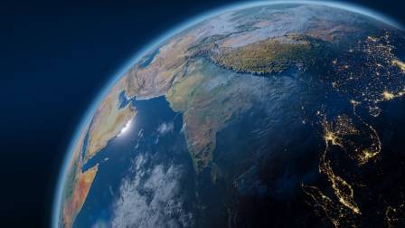
Digital Earth represents an ambitious idea centered on building a detailed virtual version of our planet. By combining extensive geospatial data, it enables a more comprehensive understanding of Earth’s natural systems as well as human activities.
Ava Simmons
City note
Sunny tip
The full plaza write-up continues below on the positive pulse board.
Board
NYC Good News
Digital Earth represents an ambitious idea centered on building a detailed virtual version of our planet. By combining extensive geospatial data, it enables a more comprehensive understanding of Earth’s natural systems as well as human activities.
Originally proposed by former U.S. Vice President Al Gore in 1998, the concept has since grown into a broad, interdisciplinary field that includes geospatial technologies, data integration, and diverse real-world applications.
Development and Background
The idea of Digital Earth was first introduced by Al Gore during a speech at the California Science Center. He described it as a multi-layered, three-dimensional digital model of the Earth that would allow people everywhere to access and explore vast geographic datasets. His vision emphasized its value in education, environmental analysis, and decision-making, with a strong focus on unifying data from multiple sources into one accessible system.
Over time, this concept has evolved significantly due to rapid technological progress and the growing availability of geospatial information. Advances in satellite imaging, Geographic Information Systems (GIS), and internet connectivity have made it possible to build increasingly detailed digital representations of the Earth’s surface, atmosphere, and underground structures.
Core Elements of Digital Earth
Geospatial Data Integration:
A fundamental aspect of Digital Earth is combining data from multiple sources, such as satellites, aerial surveys, and ground measurements. This integration enables accurate and detailed mapping of Earth’s features and processes.
Digital Elevation Models (DEMs):
DEMs provide 3D representations of terrain elevation, which are essential for studying landscapes and supporting fields like geology, hydrology, and urban development.
Geographic Information Systems (GIS):
GIS tools allow users to analyze and visualize spatial data, supporting informed decision-making in areas like environmental protection, transportation planning, and public health.
Remote Sensing:
Satellite and aerial sensing technologies collect data about the Earth’s surface, playing a key role in tracking environmental changes, managing resources, and responding to natural disasters.
Data Cubes:
These structured datasets store large amounts of geospatial information in multiple dimensions, making it easier to analyze patterns over time and perform complex queries efficiently.

Practical Uses of Digital Earth
Digital Earth technologies are applied across a wide range of sectors:
Environmental Monitoring:
They help track changes such as deforestation, climate shifts, and urban expansion, enabling better environmental management and policy decisions.
Disaster Management:
By incorporating real-time data, Digital Earth supports early warning systems and response planning for events like floods, earthquakes, and hurricanes.
Urban Development:
City planners use these tools to design sustainable cities, improve infrastructure, and make efficient use of land resources.
Agriculture:
Farmers benefit from Digital Earth applications by monitoring crop conditions, optimizing irrigation, and implementing precision farming techniques to boost productivity.
Education and Research:
Schools and research institutions use Digital Earth platforms to teach geography and earth sciences through interactive and immersive experiences.
Global Efforts and Organizations
Several international initiatives support the advancement of Digital Earth:
International Society for Digital Earth (ISDE):
Promotes research collaboration, innovation, and knowledge exchange in the Digital Earth field.
International Journal of Digital Earth:
A scholarly publication focusing on the theories, technologies, and societal impacts of Digital Earth.
Digital Earth Africa:
Provides open access to Earth observation data to support sustainable development across Africa.
Digital Earth Reference Model (DERM):
A framework designed to enable the integration and sharing of geospatial data from different sources via the internet.
Technologies Powering Digital Earth
The growth of Digital Earth is driven by several key technological developments:
Artificial Intelligence and Machine Learning:
These tools improve the analysis of large geospatial datasets, enabling pattern detection and predictive modeling.
Cloud Computing:
Cloud platforms make it possible to store and process massive amounts of data, increasing accessibility and scalability.
Internet of Things (IoT):
Connected devices supply continuous real-time data, enriching Digital Earth systems with up-to-date information.
Virtual and Augmented Reality (VR/AR):
These technologies create immersive environments where users can interact with digital Earth models in more intuitive ways.
Challenges and Future Outlook
Despite its progress, Digital Earth still faces several obstacles:
Data Integration Issues:
Combining datasets with different formats, scales, and levels of accuracy requires standardized systems to ensure compatibility.
Privacy and Security Concerns:
Safeguarding sensitive geographic data and protecting user privacy remain critical challenges.
Digital Inequality:
Access to Digital Earth technologies is not evenly distributed, and bridging this gap is essential for global inclusion.
Sustainability:
As data demands grow, it is important to develop environmentally responsible methods for storing and processing information.
Overall, Digital Earth continues to evolve as a powerful tool for understanding and managing our planet, with the potential to transform how we interact with geographic information in the future.
More from the plaza
BLOCK · en

Vietnamese Fresh Spring Rolls
Fresh Vietnamese spring rolls are a light and refreshing alternative to fried appetizers, and they’ve become a popular favorite for many families. Filled with shrimp, rice noodles, and fresh herbs, these rolls are delicious when paired with flavorful dipping sauces. They are also perfect for parties since they can be prepared ahead of time.
BLOCK · en

How to Make the Silkiest, Most Delicious Pudding (A Dessert That Deserves More Love)
Usually, I’m the person who shows up to a casual gathering carrying a seven-layer cake with meticulously placed pomegranate seeds set into the glaze, using tweezers. I wouldn’t suggest trying to be that person. Instead, let’s talk about pudding.
BLOCK · en

24 Best Surf Towns in the World: A Regional Guide
Whether you’re chasing perfect wave conditions or simply looking for a cool town with a surf-vibe, this guide highlights what the author considers some of the very best surf towns around the globe—organized by region and suited to surfers of various levels.
BLOCK · en

World’s Most Iconic Lighthouses: Beacons of History and Beauty
Lighthouses have long held a special place in the hearts of travelers, with their rich histories and stunning locations captivating imaginations across the globe. For centuries, these towering coastal sentinels have guided ships safely to shore, standing as enduring symbols of hope, resilience, and human ingenuity. From rugged shorelines battered by waves to serene islands tucked away in distant seas, each lighthouse tells a unique story of maritime heritage, while offering breathtaking views that make the journey to visit them well worth the effort. Here, we explore ten of the world’s most famous lighthouses, each with its own distinct charm and significance.
BLOCK · en

Unveiling the Enigma of Animal Colors: A Luminous Spectrum
Vivid, neon greens, ultraviolet masterpieces, and mesmerizing rainbows — the animal kingdom unveils a wondrous realm of colors, each with its own captivating tale. The reasons behind this kaleidoscope of shades are as diverse as the colors themselves. Let's delve into the incredible world of animal hues and discover how these enchanting displays come to life.
BLOCK · en

Manta rays possess one of the highest brain-to-body mass ratios among fish.
The giant manta ray (Mobula birostris) is the largest ray species on Earth.